


How to use the CAL FIRE Smart Map to track the Pacific Palisades wildfire


The California Department of Forestry and Fire Protection provides a real time map to track the fire status.
The CAL FIRE map includes a lot of information that's continuously updated. What is a SMART MAP? How is the map updated? How can you best use all the features?
A SMART MAP consists of a different data layers (such as roads, buildings, fire alerts...)
The map background can be changed based on what you're interested in (roads, landscape...)
Information is collected by satellites, sensors, fire fighters and volunteers
The map can be see in standard mode (2D) or as a three dimensional (3D) map that can be rotated and panned
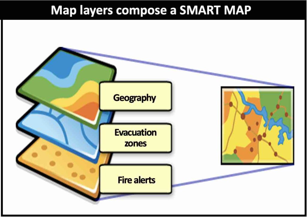
How data layers create a Smart Map
Smart maps consist of data layers which can be selectively displayed. The data in these layers come from different sources and is continuously updated. This is ideal in natural disasters such as wildfires where the situation can change in seconds. The CAL FIRE map uses ARCGIS technology from esri.

Using a 2D Smart Map
Adjust the background for the map and adjust the focus to get the best view. The dashboard at the top are visual displays that present data in an easy-to-read format. All relevant information can be seen on a single screen, facilitating understanding quickly and easily. Operational dashboards help operations staff understand events, projects, or assets by monitoring their status in real time.
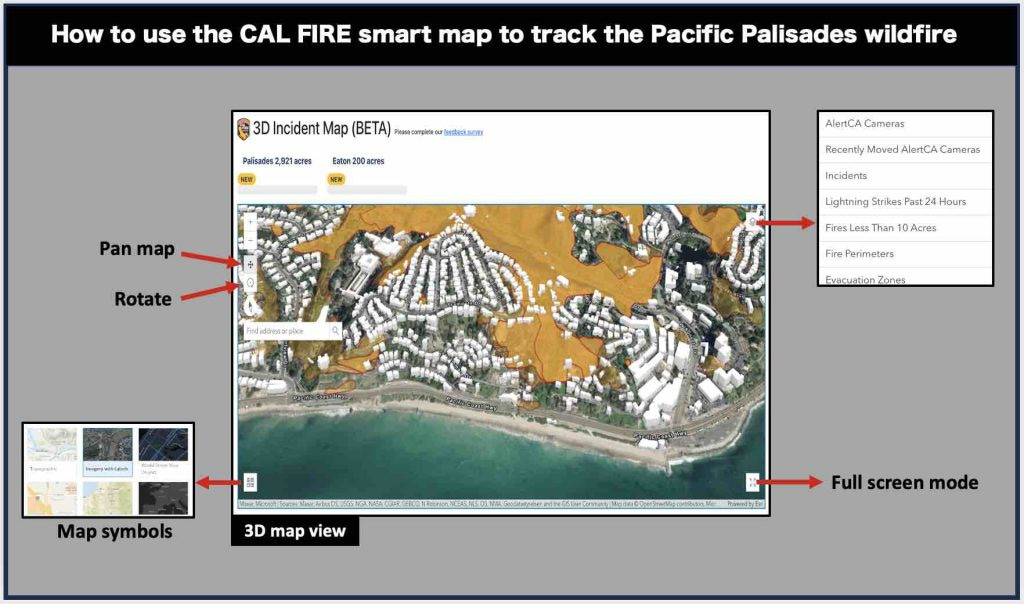
Using a 3D Smart Map
3D Map let you get a better perspective by zooming, panning and rotating the map. Evacuation routes and other details are easier to see.

CAL FIRE
CAL FIRE’s mission emphasizes the management and protection of California’s natural resources; a goal that is accomplished through ongoing assessment and study of the State's natural resources and an extensive CAL FIRE Resource Management Program.
CAL FIRE oversees enforcement of California’s forest practice regulations, which guide timber harvesting on private lands.
Reviews and inspections ensure protection of watershed and wildlife, as well as renewal of timber resources.
Department foresters and fire personnel work closely to encourage and implement fuels management projects to reduce the threat of uncontrolled wildfires.
CAL FIRE Foresters promote conservation and the importance of our trees and forests to Californians of all ages.
Take Away: Use Smart Maps to make vital, rapidly changing information quickly available to the people who need it, like CAL FIRE.
Deepak
DemLabs
DISCLAIMER: ALTHOUGH THE DATA FOUND IN THIS BLOG AND INFOGRAPHIC HAS BEEN PRODUCED AND PROCESSED FROM SOURCES BELIEVED TO BE RELIABLE, NO WARRANTY EXPRESSED OR IMPLIED CAN BE MADE REGARDING THE ACCURACY, COMPLETENESS, LEGALITY OR RELIABILITY OF ANY SUCH INFORMATION. THIS DISCLAIMER APPLIES TO ANY USES OF THE INFORMATION WHETHER ISOLATED OR AGGREGATE USES THEREOF.

CAL FIRE Disclaimer
Information presented on the departments website is a representation of the existing wildfire situation, based on the information readily available to CAL FIRE. We make every effort to provide accurate and complete information, however the data is subject to review and change. This site provides general information concerning an incident. All of our information comes from the firelines and must be approved by the Incident Commander in charge of managing the incident prior to release. As battling a fire, or handling any other disaster is the priority, updates to these sites cannot be guaranteed on a set time schedule. Please use the information on these pages only as a reference. The sites are not meant to provide up-to-the-minute evacuation or fire behavior information.
Please refer to the fire information phone numbers provided on this site, and website links for additional information, and monitor your local radio stations for emergency broadcasts. If you live in a wildland area always have an evacuation plan in place. Fires occur throughout the State within CAL FIRE jurisdiction on a daily basis during fire season. However, the majority of those fires are contained quickly and no information will generally be provided on these incidents at this site if the fire burns less than 10 acres. If you would like to obtain information about a CAL FIRE fire burning in your area that is not included on this web site, please contact the CAL FIRE Unit that services your county.